|
The Equatorial Bulge Climbing Equador's Volcanoes February 27th, 2006
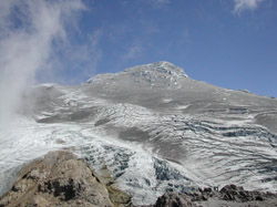
Cayambe (19,000 feet) is Ecuador's third highest peak, and boasts the world's highest point on the equator, which passes through the southern slope of the mountain. A fairly gentle four-wheel drive road leads to the surprisingly plush hut at 15,200 feet on the southwest side of the peak. From the hut, a short hike leads to a tongue of Cayambe's southern glacier, where ice climbing and crevasse rescue techniques can be practiced. Unfortunately, the conditions on the volcano are the worst in decades. The November 2002 eruptions of Reventador coated Cayambe in a layer of heat-absorbing black ash, which has widened crevasses, collapsed bridges, and caused the formation of gnarly penitentes. These peculiar towers of ice reach up to four feet tall, making for tough glacier travel conditions, indeed. In addition, the ash itself has made route-finding on the glacier a real pain, since features can't be seen in the dark. As a result, it is surprisingly easy to stray from where you want to be. If you do intend to climb Cayambe, try to go with someone who has recently done the route, and time your effort with at least a half-moon. Get an early start (midnight) and ascend the trail network up the rock cliffs behind the hut. Reach the lower glacier at 15,600 feet and rope up. Attain the glacier and aim for the lower of two prominent rock fins that protrude from the ice. These fins can't be seen on a moonless night, so pay close attention to where you're going. Ascend and pass the lower rock fin, either on the right or left (the left is probably easier). Whichever way you choose, stay close to the rock—if passing on the right, don't venture too or you'll end up in a maze of crevasses. If passing on the left, don't venture too far or you might end up on the north face of the mountain, hell-and-gone from where you want to be. Despite the descriptions in several guidebooks, there currently is no ice or rock cliff above the lower rock fin. Instead, from just above the lower rock fin, head straight up the glacier to the right, marching over penitentes and avoiding crevasses, aiming for the massive summit block. Again, this summit block is difficult to see against a moonless night sky, so you may want to take a compass bearing once you arrive at the top of the lower rock fin. Ascend the huge slope of ash-covered ice to about 17,800 feet on the south/southwest face of Cayambe's summit block. Here is where things get especially tricky. Currently, the proper route requires a circuitous easterly traverse high up the mountain to find a steep, icy breach. This breach tops out in a tremendous channel of ice, reminiscent of the Death Star trench from Star Wars. Another steep breach leads out of the trench to an ice shelf, beyond which is a 200-foot high ash-covered wall of 40-degree hard, penitented snow. At the top of the wall is the famous “big crevasse” and the crux of this route. The crux requires a scary vertical 10-foot downclimb into the crevasse, then a scarier climb back out. Far beyond the crevasse is the summit, an expansive bulge of snow. Although it is only about 200 vertical feet higher, it takes another hour to get there from the crux.
Cayambe is an enormous climb, made especially challenging by the difficult route-finding, and the necessity in many cases to protect the steep sections, as well as the crux itself. It is important to keep careful track of time, as the midday sun can weaken crevasse bridges and reduce visibility by boiling up thick fog. If you don't hire a guide, try to follow another party that has one. Get an early start, take lots of beta, and carry a photo of the mountain. The day before your climb, ascend the rock trail up to the glacier to get a good, close look at the route in daylight; locate the lower rock fin, plan your intended line of ascent, and mark it on your photo. Cotopaxi (19,300 feet) is a magnificent volcano of nearly perfect conical symmetry—this beauty alone makes it a worthwhile climbing objective. Coto is also Ecuador's second highest peak, and the most popular and well known of the Big Four. A good dirt road leads from the Pan-American Highway to the main trailhead at 14,700 feet. From here, it's an easy 45-minute hike to the hut.
It is claimed that, statistically, Coto has the best weather of any peak in Ecuador, but don't count on that. If you do have decent weather, Coto is probably the most straightforward of the Big Four to summit and can readily be climbed in four and a half hours by a strong party. Despite its smaller scale, Coto's normal route is probably the steepest of the Big Four, and may average well over 40 degrees. The steepness begins immediately after attaining the glacier. Follow the trail of wands and footprints as it winds around several huge but easily avoided crevasses. If the weather is lousy, an ice cave at 18,000 feet offers shelter. Shortly after the cave, you will come to several steep sections leading up to an ice step just beyond a small, but deep crevasse. This step is probably 55 degrees and is the route's crux. It requires about 15 feet of front-pointing over hard snow or ice. Many guides protect this step, since a fall here could be disastrous. Beyond the crux, the steepness and difficulty relent a bit and a long 40-plus degree slope leads to the broad summit. Chimborazzo (20,700 feet), Ecuador's highest peak, is, for many, the grand prize. Due to equatorial bulge, Chimbo supports the farthest point away from the center of the earth, so, by this measure, it is the highest mountain in the world. Find a ride to the parking lot at the lower hut (from Riobamba, taxis are about $30), from which an easy 45-minute hike takes you to the upper hut at 16,200 feet. As you approach Chimbo, the view is quite intimidating, but it's not as hard as it looks. The day before your climb, take the time to scout the approach and lower glacier. The route-finding on Chimbo's northwest route is easier than on Cayambe's southwest route. Nevertheless, due to the sheer size of this mountain, very few people attain the “Whymper” summit. Most stop at the “Veintimilla” summit, which is about 0.6 miles west and 150 feet lower than Whymper. If you intend to stand on Whymper, don't waste too much time route-finding on the ascent. Page 4 »
|
||||||||||||