|
The Equatorial Bulge Climbing Ecuador's Volcanoes February 27, 2006
Bonus Peaks Route-finding can be somewhat challenging on Iliniza Sur, so be sure to carry a photo of the route, and, if possible, scout to the west end of the saddle the day before your climb to find the black-ice gully.
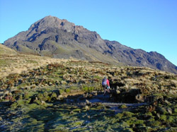
The Big Four Antisana (18,900 feet) is Ecuador's fourth highest peak, and the most glaciated and difficult of the Big Four. It is arguably the most astonishing and spectacular mountain in Ecuador. Unlike Ecuador's other big peaks, Antisana is extremely remote; there are no towns, farms, or settlements within an hour's drive of the base and there is no hut. What's more, the dirt roads are gnarly; only serious off-road vehicles can reach the base of Antisana. For all of these reasons, you are not likely to see other people on this mountain. While many climbers will welcome the solitude, remember that if something goes wrong, you'll be on your own. Regardless, Antisana is definitely worth going out of your way for. It offers 3,200 feet of awesome glacier climbing, almost twice as much as Iliniza Sur. Antisana's summit cone is an astonishing place—to walk among those gaping crevasses and gigantic towers of broken, jagged ice is truly an unforgettable experience.
Because Antisana has no hut, parties must bring their own shelter. Climbers attempting the west face direct route to Antisana's cumbre maxima (main summit)—the easiest route on the peak—will find plenty of good camping spots on the páramo at 14,800 feet. You could camp higher, near the start of the glacier at 15,600 feet, but this moraine is quite rocky and good campsites are hard to find. From camp, hike up the moraine on a vague trail system to reach the lower tongues of Antisana's western glacier. These tongues are low-angle, and will probably crack and pop as you trample over them. As you progress higher, the route gradually gains steepness, reaching about 45 degrees just below the fearsome summit block. Ascend to a broad ledge just below a steep, 150-foot mound of snow. The route finding is easy—up to this point. But before you celebrate, be aware that, from this ledge, you can't see the difficulties that lay ahead. All that is visible from here is the prominent 80-foot vertical ice wall that looms over the west face like a turret. What isn't visible until you reach the top of the snow mound (about 18,600 feet) is a huge depression of ice guarding the wall. This depression encircles essentially the entire summit cone like a moat. The problem with this moat is that it's filled with a wreckyard of crevasses and ice towers. Due to the inherent instability of these features, the route from this point up changes by the month, and is therefore impossible to describe. Usually, the easiest line to the summit is accessed on the north side of the peak, so a traverse through the moat can sometimes be found to the left. Unfortunately, this cannot be guaranteed. Certainly, there are occasions when only experienced technical ice climbers can make it through the obstacles in the moat. Most parties fumble around searching for a “reasonable” line, but fail to find one. As such, your chances of standing on Antisana's summit are much higher if you climb with a guide who has done the route recently. Page 3 »
|
||||||||||||